
YEAR 12 GEOGRAPHY
RESIDENTIAL TO CRANEDALE
March 2020
By Freddie Charlesworth and Eleanor Hunt: Geography Ambassadors
The Cranedale trip is organised annually to give AS Geography students the chance to familiarise with key physical geography data collection methods ahead of NEA coursework later in the year. The trip lasted two days with one night being spent away at the centre as a group of fourty-two students and three A-level teachers from IGS.
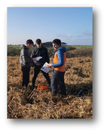
The first day was centred inland and considered the effect of afforestation on soil moisture uptake as well as other factors such as soil carbon content. This involved making a direct comparison between an afforested and deforested drainage basin in Dalby Forest; we completed sampling for one site and compared to a known data set. A level field work is much more focused on quantitative measurements as well as justification and analysis of the choice in technique, this is when compared to physical investigation at GCSE. We used new methods to collect data, such as using a hydro prop to calculate the velocity of water passing downstream and quantitative chemical testing to measure water carbon contents. Fortunately, the weather was in our favour and made the outdoor section of the course much easier than being stood in torrential rain. We progressed to consider the analysis of soil, which involved some unconventional yet effective methodology to measure percolation rate. Data collection techniques proved varied, in some cases using sophisticated equipment whilst also using simplistic techniques to complement and give a comprehensive set of data to verify our hypothesis.
Despite feeling tired, the work continued after dinner with a two hour session covering statistical testing methods. Statistics play an important role in answering a fundamental question when trying to prove a statement: ‘coincidence or truth.’ Methods such as the chi-squared test for proofing ensure that conclusions are genuine. After work was completed we retired to use the facilities at the centre, this included: a bar, table tennis, cards and just a nice environment to unwind in ahead of the next day on the Holderness coastline.
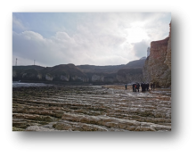
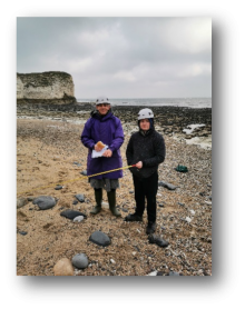
On Friday 7th April we went to Selwicks Bay on the Holderness Coast. It was nice to see the bay that we have seen so many times in textbooks and on PowerPoints in real life. Here we spent the morning measuring the angle of the beach using a SILVA Clinometer at different distances and then calculated the overall beach angle. We also measured sediment size at intervals to establish the dominant sediment size of this bay. These are fieldwork methods that could be used on our NEA’s in Year 13. But, on the wave cut platform (a typical landform of erosion) it was fairly cold and windy so to get warm and keep clear of the incoming tide we ate our lunch in the van and headed back to the Cranedale Centre. In the classroom we were able to use some of the statistical tests we had learnt the day before and construct a beach profile diagram of Selwicks Bay. Once we had finished this it was time to head home, it was a quiet coach trip back with many tired year 12’s.